Skip navigation

Category Archives: Moonrise

I happened to be in Duluth, Minnesota during the last Blue Moon so I walked down to Canal Park to take some photos of it rising over Lake Superior. It was a beautiful night and people were walking along the breakwaters. Quite a few of them were surprised when the moon came up over the lake.

Blue-Moon-South-Breakwater-Light-Duluth-15-8-_1492

Blue-Moon-15-8-_1499

Blue-Moon-Duluth-Breakwater-Lights-15-8-_1575

Crex Meadows is located just outside Grantsburg, Wisconsin. It is one of the premiere locations to watch the fall migration of Greater Sandhill Cranes. In early October the Cranes start arriving in Crex to rest and feed before resuming their journey to the golf coast where they spend the winter. During peak migration there are approximately 30,000 Sandhill Cranes in the Grantsburg area. The migration continues until the marshes ice over in mid to late November.

Before making our trip to Crex Meadows we check out their great website for the latest information regarding the migration.

Sunset-Crex-Meadows
My wife and I usually spend the greater part of two days watching and photographing the Migration. Crex is a couple of hours northwest of our home so we usually plan to arrive in the Grantsburg area early in the afternoon of the first day.Crex-Meadows-Sandhill-Cranes-12-10-_0754
During the day the cranes are out in the farm fields south of Grantsburg. We drive north on highway 87 toward Grantsburg. Once we reach the junction of highway 48 and 87 we start looking for cranes. We can usually find where the cranes are feeding by watching the sky. In the afternoon they seem to start to gather into larger groups for the flight back to the Crex marshes.  Sometimes there are large numbers of birds right along highway 87. At other times it is necessary to drive the back roads east of highway 87 and north of highway 48. If we spot a flight of cranes we watch were it is heading and follow it. There are large bean and corn fields in the area and they can provide a great place to view the cranes during the day. We usually drive around looking birds in the fields in the early afternoon.

Sandhill Cranes

Sandhill Cranes

Before heading out to Crex Meadows our first stop is always at the visitors center to check on current conditions. They will have up-to-date information on where the cranes are going to be roosting. You will also be able to pick up some good maps of the area. On your first trip you might find the many roads around Crex a little confusing.Sandhill-Cranes-13-10-_2674

After checking in with the visitors center we like to drive around the entire area to check things out and see what else in happening in the meadows. We have seen American Beaver, Bald Eagles, Trumpeter Swans and a variety of ducks and geese as we drive around. Typically during the afternoon things are fairly quiet in the meadows with most of the cranes out feeding.

Trumpeter Swans

Trumpeter Swans

We always stay overnight at the Grantsburg Inn in Grantsburg. This allows us to photograph the incoming flights at sunset and the outgoing flights at sunrise the next morning without a lot of driving.

Sandhill Cranes Sunset Flight

Sandhill Cranes Sunset Flight

About an hour and a half before sunset we head toward the location where we will be watching and photographing the evening flight of the cranes into the sledge marshes. Typically the best location to view the evening flight is along Main Dyke Road between East and West Refuge Roads. The flight in to the evening roosting grounds is directly over Main Dyke Road. No matter where you stop it appears that more birds are flying over another section of the road but if you wait you will be rewarded with plenty of birds. The best location on the road may depend upon the stage of the migration and the water levels in the sledge marshes. The evening flight can last several hours. As sunset approaches you will start to see large numbers of Sandhill Cranes flying into the sledge marshes to nest for the night. Groups of birds can range in size from just a few to over twenty. On this particular evening I was lucky to get some black storm clouds in the background.Sandhill-Cranes-09-126--534f

In addition to the cranes there can also be some spectacular sunsets in the marsh.Sunset-Crex-Meadows-10-_9632

As the evening progresses and the light gets low you can produce some special effects by slowing the speed down.Crex-Meadows-Sandhill-Cranes-Evening-Flight-12-10-_1040

The next morning we typically try to be in the meadows about an hour before sunrise. Fortunately the local BP station is open early so we can get some coffee and donuts. If it looks like there is going to be a an outstanding sunrise on Phantom Lake we stop for some quick dawn or Sunrise photos.Sunrise-Phantom-Lake-Crex-Meadows-11-11-_0761

Even after sunrise it is easy to get distracted if there is a nice frost or morning fog.Sunrise---Crex-Meadows-09-127--092

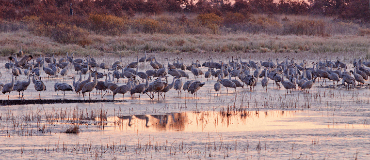
Eventually we make our way to the roosting grounds. When the birds fly into the sledge marshes in the evening they are generally well back into the marshes. Overnight the cranes usually move much closer to Main Dyke Road.  Several years ago when the water levels in the marshes were very low they could be found right next to the road.Sandhill-Cranes-11-11-_0045

As the sun comes up you can get some nice morning light on the birds as well as reflection shots.Sandhill-Cranes-11-11-_0303

If you are lucky there might be some nice clouds as a background. The morning flight can last in excess of three hours. In the morning the birds move out in smaller groups as opposed to the evening flight where there can be a large number of birds in each group.Sandhill-Cranes-Crex-Meadows-11-9-_1476

I’ve photographed at Crex Meadows for a number of years and have a few things you might want to consider in planning your trip.Crex-Meadows-Sandhill-Cranes-Sunrise-Flight--12-10-_0555

Crex can be very busy on a weekend or if there are fall events underway. Checking the Crex Meadows website should tell you what is going on at any given time. I usually try to plan my visit on a weekday when there is likely to be less traffic.Crex-Meadows-12-10-_0851

There is only one motel in Grantsburg. The other option is the local campground which is popular with visitors. Staying in Grantsburg makes it much easier to photograph the sunset and sunrise flights.

Sandhill Cranes Morning Flight

Sandhill Cranes Morning Flight

If you visit early in the migration you will likely find a lot of standing corn in the fields. This makes it more difficult to see the cranes while they are feeding in the fields. This doesn’t mean you won’t see cranes. You can still find them feeding in open areas and pastures but probably not in the numbers you will see later after the corn has been harvested.Sandhill-Cranes-10-_9381

Early in the fall you can enjoy the fall colors as the trees turn. Later in the fall most of the leaves will have fallen although the sledge marshes still have a lot of color.Crex-Meadows-11-9-_1652

As I noted earlier the best place to view the evening and morning flights of the cranes is on Main Dyke Road. This is true for most of the migration. However, later in the season, when the marshes ice over the cranes can roust at different locations. One year late in the migration we found there was no evening flight over Main Dyke Road because the cranes were rousting at Phantom Lake. A stop at the visitors center should identify where they are rousting.Sandhill-Cranes-09-126--569

Another thing to keep in mind is the dyke roads are dirt. If there has not been any rain they can be very dusty so you need to plan on protecting your photographic equipment from the dust and giving it a good cleaning after the visit. Particularly on weekends there can be quite a bit of traffic kicking up dust.Crex-Meadows-12-10-_0849

If you plan your visit ahead and the weather is good you may get some great moon shots while watching the evening flight of the cranes.Flying-over-the-Moon-10-_9465a

The fall Sandhill Crane migrations if one of the things we look forward to and we think you will enjoy it as well.

Last weekend there was a full moon which was scheduled to rise over the Duluth Aerial Lift Bridge. I walked down to Bayfront Festival Park to watch it and I wasn’t alone. Many of the folks that were in the Park to watch the balloon Festival ended up checking out the moonrise.

Aerial-Lift-Bridge-13-9-_0974

Aerial-Lift-Bridge-13-9-_0987

Aerial-Lift-Bridge-13-9-_1009

Earlier this week we drove up to our condo in Duluth, Minnesota. It was going to be around 100 degrees at home and we decided that was a bit too much. We hoped for some cooler weather around Lake Superior. About 15 miles from Duluth it was already over 90 degrees at 11am. By the time we reached Duluth the temperature had dropped to 70 degrees. The second day was in the 80’s with high humidity and was miserable. The next day started out like it was going to be another hot one but the wind shifted and a north east wind turned on the Lake Superior air conditioning and the temperatures ended up in the 60’s, 40 degrees cooler than at home.

The trip just happened to coincide with a full moon. I checked The Photographer’s Ephemeris (TPE) and it looked like there was a good chance of catching a photograph of the full moon rising over the North Breakwater Light as well as some sunrise shots around Canal Park. Several years ago I captured a great shot of the moon rising over the South Breakwater Light and wanted to get a matching photo.

Moonrise over South Breakwater Light

Unfortunately TPE can only do so much. It turned out there was a haze over the Lake Superior and by the time the moon had risen above the haze it was not possible to get a shot of the moon over the North Breakwater Light. I did hang around for a while and was able to get a shot of the moon through the Aerial Lift Bridge.

Moonrise over Arial Lift Bridge

The next morning I didn’t quite get up in time to make it down to Canal Park for the scheduled sunrise. Fortunately there was a haze over Lake Superior. As a result the sun didn’t rise above the haze until about 20 minutes after normal sunrise so I was still able capture some delayed sunrise shots.

Sunrise South Breakwater Light

Sunrise North Breakwater Light

Anchor Canal Park

Moonrise Crex Meadows

One of the things I like to do is try and plan my photography trips so that the sunset and moonrise are in close proximity. This allows me to get great shots of the sunset and turnaround and get a shot of the moonrise. The first time this happened was an accident. I had been photographing the sunset at Crex Meadows and was packing up to leave when I turned around and notice a full moon over Phantom Lake. After this experience I started checking the sunset/moonrise tables to plan my trips.


Moonrise over Crex Meadows

On a later trip to Crex Meadows I had planned to photograph the sunset and moonrise and had picked a great day to capture both. I picked a new location to photograph the sunset. Unfortunately I picked a bad location and didn’t get any sunset photos and almost missed the moonrise because I was in the wrong location. That was when I started to use The Photographers Ephemeris to plan my trips. This program not only shows the times for the sunset and moonrise but also shows the direction of the sunset and moonrise from any location. This program allows me to determine the best location to get the shots I want.  I reviewed this program in an earlier post and highly recommend it to anyone doing landscape photography.

Moonrise Two Harbors

Moonset Two Harbors

Sometimes I just get lucky. Earlier this fall I was photographing at Two Harbors, Minnesota and had planned to photograph the moonrise. I got engrossed in photographing a piece of ice and almost forgot about the moonrise until my wife mentioned it and when I looked up it was already fairly high in the sky. The next morning we went down to photograph the sunrise and I noticed that the moon was setting over the ore docks in the harbor.

Moonrise Duluth Harbor

If you plan a bit you can also get some interesting shots. This was taken in Duluth Harbor and shows the moon rising out of the chimney of the Outer South Lighthouse. I knew the moon would be coming up over the harbor so I waited around for it to get to right location. Fortunately the breakwater allowed me to position myself to get the photo.

Union Bay Moonset

Other times planning doesn’t enter into things. Last fall I was planning to photograph the sunrise at Lake of the Clouds in Porcupine Wilderness State Park. As I left the motel I noticed there was considerable cloud cover in the east so it didn’t look good for a  sunrise shot. However, as we were driving into the park I noticed the moon setting over Union Bay and quickly decided that the moonset was going to provide a better opportunity on this particular morning.

More photos of moonrise/moonset photo can be found on my website. Just click on search and enter moonrise or moonset.

When we travel to the Minnesota North Shore we sometimes stop at Two Harbors for the evening. I like to photograph in the harbor at sunset. On this trip we were having problems deciding where the trip would take us. We finally decided that our destination would be Two Harbors. As a result we managed to get a late start so we didn’t arrive in Two Harbors until late in the afternoon. Our first stop was the harbor to check out conditions. The lake had some nice waves and a little ice. The Duluth Shipping Schedule indicated that an ore carrier would dock about the time we arrived but it had already arrived. I took a few shots of the waves and ice before heading for the hotel.

We changed into some warm clothing and drove back to the harbor to photograph the sunset. We were a little late and missed the early part of the color but I was able to get some interesting shots of the ice and rocks with the sunset reflecting on the rocks.

There were not a lot of clouds out but the alpenglow produced some stunning silhouette shots of the lighthouse at the end of the breakwater. The color was just spectacular.

One of the things I hopped to accomplish was to photograph the sunset and the moon rise. I usually try and plan a trip to a location where I can shoot the sunset then turn around and capture the moonrise. On this particular night I apparently had what the kids call a brain f—. I was so interested in trying to capture this small ice shot that I totally forgot about the moonrise until my wife commented that the moon was up. I was able to get a shot but not the one I wanted.

 I also managed a few shots of the ore loading docks. Although we missed the ore boat that was supposed to dock earlier in the afternoon we were able to see two ore carriers loading at the docks. Late in the evening the ore docks and ships were all lit up.

 In the morning we returned to photograph the sunrise. I’ve never been a big fan of the sunrise at Two Harbors but since we were in town I decided to give it another try. On this particular day the temperature was not that cold but the wind was really howling. It was almost difficult to stand up. The strong winds off the lake made for an unpleasant photography experience. I did manage a shot of a memorial bench located above the beach with the color on the horizon in the  background. It made for an interesting silhouette shot.

 There was also a shot of the moonset that was taking place behind the ore docks. It was still a little high in the sky but I managed to capture it.

Most of the time was spend shooting ice formations along the water. There was an Eagle wind surfing in the harbor most of the time we were there. The plan was to drive over and try and get a shot of it but it disappeared just as we were leaving.

More Two Harbors photos can be found on my website.

Seney National Wildlife Refuge Sunset

The Photographer’s Ephemeris  (TPE) is one of those programs that every landscape photographer should have. I have been aware of this software for some time but never got around to downloading and using it until a recent incident. I was photographing in Crex Meadows in May. I had gone up to photograph the sunset and moonrise. I picked out a new location for a sunset photo only to discover that the sun was setting in the wrong location. By that time I also discovered that I was in the wrong place to photograph the moonrise. That was the last straw. When I came back home I immediately downloaded Photographer’s Ephemeris and started using it to plan a trip to the Superior, Wisconsin area where I wanted to photograph the Wisconsin Point Lighthouse with the sun behind it. I was also looking for a location in the area to photograph the sunset. Photographer’s Ephemeris  provided me with the information to accomplish both goals.

Wisconsin Point Lighthouse Sunrise

Now before I travel into an area where I will likely be photographing the sunrise or sunset I check Photographer’s Ephemeris before I make the trip.  On a recent trip to the U.P. of Michigan I used it to plan photographic locations in Escanaba, Seney National Wildlife Refuge and Pictured Rocks National Lakeshore outside of Munising, Michigan. The one thing the program does not do is tell you whether or not you will have a great sunrise/moonset or sunset/moonrise but it can put you in the right place for a successful shot.

Wisconsin Point Lighthouse Sunset

The Photographer’s Ephemeris is available free for Mac/Windows and Linux computers and is available for a small fee for iOS from ITunes. There is now a version available for the Android phone. TPE also requires you acquire a copy of Adobe “AIR” which is also free. The creator does ask for a donation to help the continued development of the desktop version of The Photographer’s Ephemeris.

Grain Elevators Superior Wisconsin Sunrise

When the Android version came out I quickly purchased it. I still use my computer for trip planning. Once on location I use the Android version to identify the exact location I want to be at sunset/moonrise or sunrise/moonset. The Photographer’s Ephemeris was a very simple install on my desktop and laptop. As I noted you need to install Adobe”AIR” on your computer then download The Photographer’s Ephemeris. Once I was finished with the download and install I found the software was intuitive enough to start using without reading or viewing the tutorials.

Sand Point Lighthouse Moonrise

The Photographer’s Ephemeris is a software package that allows you to plan where the sun and moon will be in relation to a specific location at a specific time. In the example I mentioned above I wanted to photograph the sun rising behind the Wisconsin Point Lighthouse. I knew from a previous trip that this would likely take place around the summer solstice but I didn’t know just when. Viewing the location using The Photographer’s Ephemeris I could see the times that I would most likely be able to get this shot.

Seney National Wildlife Refuge Sunrise

The Photographer’s Ephemeris uses Google Maps as its basis. When the program opens you have  a search bar at the bottom of the screen. Simply type in the location and Ephemeris takes you directly to the location. A red marker will appear on the map indicting the location. Lines will appear on the screen indicating the direction of sunrise/sunset and moonrise/moonset. You have a choice of street maps, satellite imagery, imagery with street names or street maps with terrain. The program allows you to drag the marker around the map or use key commands to move it. You can move the red marker to the exact location you will be photographing from.

Pictured Rocks National Lakeshore Miners Beach Sunset

After using it a couple of times I found there were a several of things I though the program should be able to do including moving the red marker into the area you are looking at. Sure enough the program allows you to do that. All I had to do was go though the great tutorials.

I strongly recommend this program for any landscape photographer.

On May 16th and 17th I made my spring trip to Crex Meadows. I usually vary the trip time each year. This year I wanted to see the newly hatched goslings. Highlights of the trip were the goslings, watching a controlled burn in the meadows, Sighting a family of beavers and an encounter with a black bear.

Canada Geese

Although I didn’t get any great shots of the goslings they were sure fun to watch. For some reason they like to congregate on the dike roads that run throughout Crex Meadows. When a car comes down the road they wait until the last minute and then run in every direction. It reminded me of an old time silent movie skit. They would usually end up in the water only to return to the road shortly after the car drove by. In one case the parents flew into the flowage leaving the goslings to scramble over the grass and brush to get into the water. This is a shot through my windshield as I approached some geese.

Goose Swan Encounter

I noticed some Trumpeter Swans in one of the flowages and stopped to take some photos. Just as I drove up a pair of Canada Geese and their goslings entered the water near the swans. One of the swans was upset and went after one of the geese. Unfortunately I was only able to capture the end of the encounter.

Controlled Burn

I noticed that a controlled burn was taking place because I could see the smoke for miles. As I drove on the various dyke roads I managed to drive through the area they were burning. Lots of equipment and people conducting the burn. I had hoped that it would continue through sunset so it would create a nice glow but it didn’t.

Moonrise over Crex Meadows

Normally I like to plan my trip to Crex Meadows to coincide with the full moon. In this case I noticed that the full moon was a couple of days away and more importantly the moonrise and sunset were within a few minutes of each other. It makes it handy to capture both if the weather cooperates. Unfortunately it didn’t on this trip. There wasn’t a cloud to be seen. Even worse I was looking for a new area to photograph the sunset and it didn’t work out and so I was out of place to photograph the moonrise. I did manage a few shots but nothing spectacular.

Lilly Pads

I normally say in Grantsburg overnight so I can photograph the sunrise. Again it was a disappointment because there were no clouds to be seen and there were no birds on Phantom lake. However, I did manage to get some nice backlit photos of lily pads and reeds.

BeaversDriving past one of the canals in the wildlife area I noticed several beavers swimming down the canal. I drove along a parallel road and was able to get ahead of them. I setup the camera and waited for them. Unfortunately they were backlit but when they reached me they went up on land. Turns out it looked like a family. The adult was on shore and the two smaller ones swam up to it. Watching them swim I didn’t realize how large they are.

Ring-Necked Ducks

I then headed drove through the burn area on my way to the sand blow. There were still logs and stumps smoldering. Just as I started my drive through the burn area I found a pair of Ring-necked Ducks in a small pond. As I watched them a Mallard Duck came out of the reeds and started after them.

Shortly thereafter I had a surprise encounter with a large black bear. I was driving along the road at about twenty five miles an hour in a place I didn’t expect to see any wildlife when all of a sudden a large black bear charged out of the swam right in front of the car. He hit the road running full speed headed down the road in front of me. I was so surprised I didn’t even have time to hit the brakes. I followed him for about seventy five yards before he veered off the road into the swamp. You might think I got a great picture having three cameras sitting on the passenger seat. But I was so startled that I forgot to grab a camera as I followed the bear down the road at twenty five miles an hour.

Wolf Tracks

At the sand blow I managed to photography what appears to be some wolf tracks. I never know what I’m going to find at the sand blow. Last year I found some fresh bear track.

Trumpeter Swan

Driving out of the meadows I found a pair of Trumpeter Swans along the road. I typically don’t find them in the road and even when they are close to shore they usually move out into the water. This pair wasn’t about to move. They held their ground.

Canada GooseOn my way back home. I stopped at the Fish Lake Wildlife Area to watch some birds. As I watched several Canada Geese in the water another goose flew down and landed on top of one of the geese I was watching. It  pushed it entirely underwater. I had never seen anything like this. The goose popped back up and they swam off together.

All in all it was a successful trip with the fire burn and bear encounter. Crex Meadows is a great place to photograph wildlife because of the extensive dyke road system that allows you to photograph from the car without disturbing the wildlife.

More photos from Crex Meadows can be found on my website.

.