We normally make a trip to Pictured Rocks National Lakeshore in early June. This year we were busy with other things and this past weekend was the first chance we had to make the trip. It’s a long drive so we ended up taking a four day weekend for the trip.
Day 1
The first day is normally a long driving day. It takes about seven hours to reach Pictured Rocks and usually a little longer if we make any stops. The weather report was for a cloudy day so we decided to try and stop at some waterfalls in order to break up the trip.

Bond Falls
The first stop was at one of my favorite waterfalls, Bond Falls. It had been cloudy the entire trip and I like to shoot waterfalls on cloudy or overcast days because it provides a more even light. As luck would have it as soon as we reached Bond Falls the sun came out. I seemed to be cursed on my visits to Bond Falls. The trip to the falls is generally made with overcast skies and as soon as I arrive the Sun comes out. Bond falls is below a dam so there is always a good flow of water over the falls. This shot was made at a small waterfall above the main falls.

Ferns
Our second stop of the day was at Canyon Falls which is just a short driving distance from Bond Falls and was on our way to Munising. I thought the U.P. might have received some of the heavy rains that came through Northern Wisconsin the past few weeks and hoped that the water level was high but it didn’t happen. The water levels were low for this time of year and the falls did not offer particularly good photographic opportunities. This is a shot of some ferns growing on the wall above the falls.

Elliot Falls

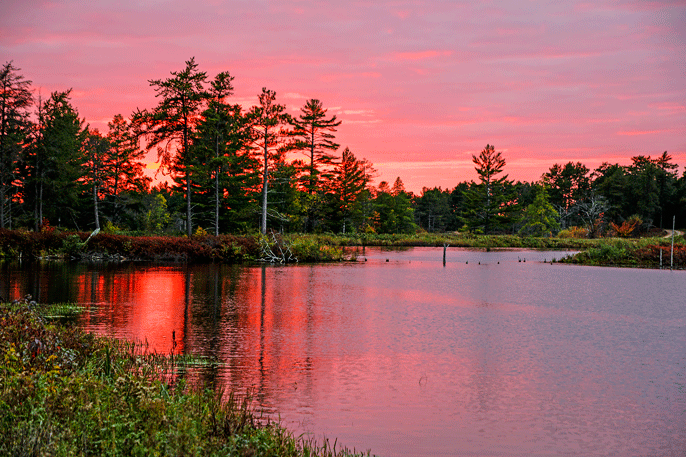
Sunset Miners Beach
Because of our stops we didn’t reach Munising late in the day. We grabbed a bite to eat before heading out to Miners Beach at Pictured Rocks. I normally photograph sunsets from Miners Beach. It can offer some spectacular sunsets and there is a small waterfall that it a popular photography location. This was one of the few visits when there was no one else on the beach. It is still early season in the U.P. so there were not a lot of other folks around at any of the locations we visited. My wife noticed that there were quite a few flies attracted to her boots but I didn’t notice them. It turned out this was significant but we didn’t realize how significant until the next Day. The shot on the left shows the sunset. I’ve seen a lot better at Miners Beach but it was still nice. The lake was very calm so there wasn’t much wave action. The shot on the right shows Elliot Creek Falls as it emerges from forest.
Day 2

Pictured Rocks
Day two was a scheduled hiking day. We decided to drive back to Miners Beach and hike from Miners Beach over to Mosquito Beach. It’s about a six mile round trip and it was our first time on this portion of the Lakeshore Trail. The first few hundred yards are very steep and hard on someone with bad hamstrings. There were a wide variety of flowers out but not a lot of each type of flower. It looked like in a week the woods will once again be carpeted with wild flowers. There are some good places to view the lakeshore from along this portion of the Trail.

Sand Patterns

Birch Tree
On the second observation point we got an inkling of what was to come. We walked out into the sand and were immediately covered with Stable Flies. We quickly headed back onto the main trail but the flies remained with us. It made for a miserable day because every stop we picked up more flies. For the most part they just hang on to your clothes but they will bite exposed skin. The last thing you want to do on a warm day is wear long pants and shirts but it is the best course of action. Fortunately they don’t cause large welts when they do bite. Insect repellents have no effect on them. We later found out that they cluster along the beach on hot days, it was close to 80 degrees, when the wind is out of the south. We ended up hiking the entire trip without any breaks. Three young people had started out hiking ahead of us and we met them as they were running back to the trailhead. This was our first and hopefully last experience with Stable Flies. They were out early this year. One of the rangers said they were first seen in May this year. The shot on the right shows some sand patterns at Mosquito Beach and the left is of a Birch Tree with the lake in the background.

Wagner Falls
The presence of Sable Flies considerably reduced out options for the day’s activities. We ended up going back to the motel and watching a Euro 2012 football game. Later in the day it clouded up so we had an early dinner and then went out to photograph some waterfalls. Fortunately there are quite a few waterfalls in Munising. I think there are six of them and we stopped at four of them during the evening before driving out to sand point and hiking a short nature trail. This is a shot of Wagner Falls just outside town.
Day 3
Day three was supposed to be another hiking day. We had planned to drive to the Hurricane River campground then hike along the beach to Au Sable Lighthouse. We love hiking along the beach because it isn’t all sand and offers a variety of scenery. It is also nice because the wind is usually blowing and there are no mosquitoes. On the drive to Hurricane River we stopped at Twelve Mile Beach to check on fly conditions. As we exited the car we were immediately engulfed in Stable Flies. Well the best laid plans just went out the window and the flies came in. It took us most of the day to get all of the flies out of the car.

Goslings
Our original plans were to hike for most of the day then drive over to Seney National Wildlife Refuge late in the day. With Stable Flies at all of the beaches we decided to drive directly over to Seney and forget about hiking along the lakeshore. It was around noon when we arrived at Seney so we didn’t expect to see a lot of wildlife activity as we drove around the refuge. We drove the Fishing Loop and part of the Marshland Wildlife Drive. On the Fishing Loop we could see how close the recent wildfires had gotten to the main public roads in the refuge. There were a few birds out and we did see some Canada Geese Goslings that weren’t very old.

Boats
Since there wasn’t a lot going on in the refuge we decided we had enough time to drive over to Tahquamenon Falls before returning for some sunset photography. We had visited the Upper Falls on a trip the previous fall so we decided to try the Lower Falls this trip. I had seen better water levels and more interesting water action on previous trips so I concentrated on photographing people enjoying the river. This is a shot of the boat rental area.

Trumpeter Swans
We then drove back to Seney and had dinner at a local bar before heading back out to the Wildlife Refuge. It was about six in the evening and we had about four hours to kill before sunset. We ended up taking the Marshland Wildlife Drive twice before sunset. There was a lot to see. Seney has a large number of Trumpeter Swans. Captive swans were introduced over twenty years ago and they have flourished at Seney and are a common sight on the refuge. This is a shot of Trumpeter Swan Cygnets feeding with one of the parents. We were able to observe them for a long period of time. While they were in deeper water the cygnets would wait while the adult fed off of

Cygnet
the bottom. The adult would then bring up food from the bottom for the cygnets. The cygnets would rush over to feed on the material the adult brought up. We observed two different pair of adults. One pair had two cygnets and the other pair had four. In both cases we were able to stand on the shore and eventually they came right up to the shoreline to feed. The adults didn’t seem to be too concerned with our presence. This was definitely the highlight of our visit.
In addition to the swans we saw many other birds including Grebes, Kingfishers, Kingbirds, Loons and Canada Geese. In one location there were a bunch of Canada Geese with their teenage offspring that didn’t want to get out of the road. Every time we drove past they would run down the center of the road in front of the car until finally moving off toward the lake.

Muskrat
We also saw White-tailed Deer with their fawns walking along the road. Muskrats and Beaver were abundant late in the day. They were, well, working like beavers. In a couple of cases we could see what appeared to be small islands moving through the water. The beaver were moving so much material we could hardly see the beavers. We found this Muskrat eating on a tree that had fallen into the water.

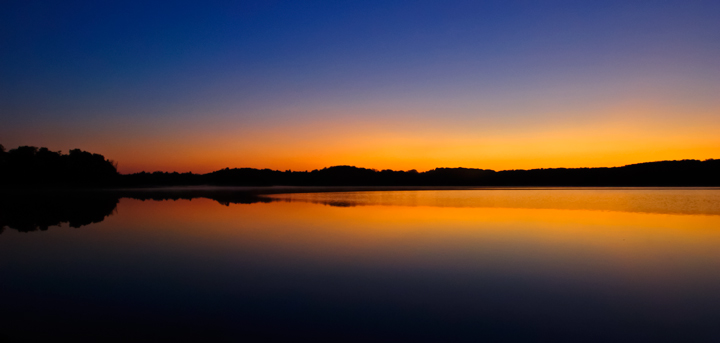
Sunset
We made one last drive, our fourth trip of the day, around the Marshland Wildlife Drive in order to photograph the sunset. I have The Photographer’s Ephemeris loaded onto my Android phone so as we made earlier trips through the refuge I used it to pick out some good locations for sunset and sunrise shots. The sunset was good but not spectacular. Unfortunately there were clouds along the horizon so the sunset didn’t last as long as we hoped.

Seney Sunset
Nothing will top the sunset photo I managed to capture last year on our fall trip to Seney National Wildlife Refuge. There were a number of Contrails in the sky at sunset and they combined with the clouds to create a spectacular image.
Day 4

Sunrise
On day four we packed up and headed out for some Sunrise photography. Fortunately, we were on eastern time so sunrise wasn’t until six in the morning rather than five. The extra hour of sleep was welcome after a long day three. When we woke up the sky was filled with clouds so I wasn’t optimistic that we would have a good sunrise. As it turns out the sunrise only lasted for about fifteen minutes before the clouds took over and it started raining. I was able to get a few shots off before things went south.
The plan was to drive down to Manistique, Michigan for breakfast. The local Big Boy had fast internet service so we used the service to check on possible waterfall locations on the route home. I knew that Marinette County has a number of waterfalls but didn’t know where they were located. As it turned out a number of them were located along our route home. All of the falls were located in county parks. The admission fee is three dollars for the day and allows you to visit all of the parks.

Smalley Falls
Our first stop was at Smalley falls. This is a delightful little waterfall that is just a short hike from the parking lot. There are a wide variety of shots to be had if you are interested in taking intimate waterfall scenes. If I had been willing to wade into the stream there would have been a few more shots. Next time I’m going we bring my waders.

Long Slide Falls
The second waterfall was Long Slide Falls. Again this was located in a county park and was only a short walk from the parking lot. Unfortunately it is difficult if not impossible to photograph the entire falls in one shot but there are smaller portions that can be photographed. The area around the falls is quite steep and since I’m no longer an agile youngster I decided to use discretion and probably missed some good shots because of it.

Daves Falls
The last waterfall we stopped at was Dave’s Falls. Again it is difficult to get a good shot of the entire falls but there are intimate shots of portions of the falls to be had. It had been raining so the rocks were wet and I again used discretion and didn’t try for a spectacular shot.
This was our last stop on the way home. The remaining portion of the trip was a little more exciting than we would have liked. We encountered severe storms west of Wausau, Wisconsin. The wind and driving rain/hail forced us to pull off of the road several times. To make matters worse Verizon seemed to be having some problems with their network connections so we couldn’t follow the storm on our cell phones. We eventually did make it home safely.